


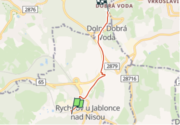

8.6 km | 10.5 km-effort
![Trail On foot Rychnov u Jablonce nad Nisou - [Ž] Rychnov u Jablonce n. N. - Dobrá Voda - Photo](https://media.geolcdn.com/t/1900/400/6d19918f-d3e9-4534-a7af-5e0a5166a0c2.jpeg&format=pjpeg&maxdim=2)

Tous les sentiers balisés d’Europe GUIDE+


FREE GPS app for hiking
 SityTrail
IGN / Geographical institutes
SityTrail World
The world is yours!
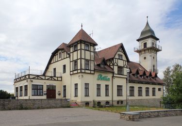
Trail On foot of 3.2 km to be discovered at Northeast, Liberecký kraj, Rychnov u Jablonce nad Nisou. This trail is proposed by SityTrail - itinéraires balisés pédestres.
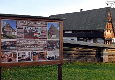
Trail created by cz:KČT.
![Trail On foot Rychnov u Jablonce nad Nisou - [Ž] Rychnov u Jablonce n. N. - Dobrá Voda - Photo 1](https://media.geolcdn.com/t/2048/auto/b124d720-3dd8-4932-a050-2f4603c98521.jpeg&format=jpg&maxdim=0 "Trail On foot Rychnov u Jablonce nad Nisou - [Ž] Rychnov u Jablonce n. N. - Dobrá Voda - Photo 1")
![Trail On foot Rychnov u Jablonce nad Nisou - [Ž] Rychnov u Jablonce n. N. - Dobrá Voda - Photo 2](https://media.geolcdn.com/t/2048/auto/6952ae12-e198-449e-9b91-e035b981eed1.jpeg&format=jpg&maxdim=0 "Trail On foot Rychnov u Jablonce nad Nisou - [Ž] Rychnov u Jablonce n. N. - Dobrá Voda - Photo 2")
![Trail On foot Rychnov u Jablonce nad Nisou - [Ž] Rychnov u Jablonce n. N. - Dobrá Voda - Photo 3](https://media.geolcdn.com/t/2048/auto/64ad5ed8-eb5e-4b2c-9047-e8ba870fcbe6.jpeg&format=jpg&maxdim=0 "Trail On foot Rychnov u Jablonce nad Nisou - [Ž] Rychnov u Jablonce n. N. - Dobrá Voda - Photo 3")
![Trail On foot Rychnov u Jablonce nad Nisou - [Ž] Rychnov u Jablonce n. N. - Dobrá Voda - Photo 4](https://media.geolcdn.com/t/2048/auto/b9b94911-02e0-45a6-a482-cbd625640f63.jpeg&format=jpg&maxdim=0 "Trail On foot Rychnov u Jablonce nad Nisou - [Ž] Rychnov u Jablonce n. N. - Dobrá Voda - Photo 4")
![Trail On foot Rychnov u Jablonce nad Nisou - [Ž] Rychnov u Jablonce n. N. - Dobrá Voda - Photo 5](https://media.geolcdn.com/t/2048/auto/f18991da-9838-44c5-ab32-f6eda6b0c694.jpeg&format=jpg&maxdim=0 "Trail On foot Rychnov u Jablonce nad Nisou - [Ž] Rychnov u Jablonce n. N. - Dobrá Voda - Photo 5")
![Trail On foot Rychnov u Jablonce nad Nisou - [Ž] Rychnov u Jablonce n. N. - Dobrá Voda - Photo 6](https://media.geolcdn.com/t/2048/auto/b8b17e6f-ce23-41c5-a543-65d57e6cb79b.jpeg&format=jpg&maxdim=0 "Trail On foot Rychnov u Jablonce nad Nisou - [Ž] Rychnov u Jablonce n. N. - Dobrá Voda - Photo 6")
![Trail On foot Rychnov u Jablonce nad Nisou - [Ž] Rychnov u Jablonce n. N. - Dobrá Voda - Photo 7](https://media.geolcdn.com/t/2048/auto/90f281c4-2d4b-4a40-a528-6fc58518bd47.jpeg&format=jpg&maxdim=0 "Trail On foot Rychnov u Jablonce nad Nisou - [Ž] Rychnov u Jablonce n. N. - Dobrá Voda - Photo 7")
![Trail On foot Rychnov u Jablonce nad Nisou - [Ž] Rychnov u Jablonce n. N. - Dobrá Voda - Photo 8](https://media.geolcdn.com/t/2048/auto/4d0d2d32-e22a-4463-9562-6077009735fa.jpeg&format=jpg&maxdim=0 "Trail On foot Rychnov u Jablonce nad Nisou - [Ž] Rychnov u Jablonce n. N. - Dobrá Voda - Photo 8")
![Trail On foot Rychnov u Jablonce nad Nisou - [Ž] Rychnov u Jablonce n. N. - Dobrá Voda - Photo 9](https://media.geolcdn.com/t/2048/auto/3ba87784-cb50-4ec3-966f-e33c47915ddc.jpeg&format=jpg&maxdim=0 "Trail On foot Rychnov u Jablonce nad Nisou - [Ž] Rychnov u Jablonce n. N. - Dobrá Voda - Photo 9")
![Trail On foot Rychnov u Jablonce nad Nisou - [Ž] Rychnov u Jablonce n. N. - Dobrá Voda - Photo 10](https://media.geolcdn.com/t/2048/auto/6d19918f-d3e9-4534-a7af-5e0a5166a0c2.jpeg&format=jpg&maxdim=0 "Trail On foot Rychnov u Jablonce nad Nisou - [Ž] Rychnov u Jablonce n. N. - Dobrá Voda - Photo 10")
On foot
On foot
![Trail On foot Hodkovice nad Mohelkou - [Ž] Hodkovice nad Mohelkou - Vrchovina - Photo](https://media.geolcdn.com/t/375/260/c8a4d6e6-c436-4c58-854e-1aa3f07f7648.jpeg&format=jpg&maxdim=2)
On foot
On foot
![Trail On foot Liberec - [Ž] Nad Kunraticemi - Milíře - Photo](https://media.geolcdn.com/t/375/260/249d98fd-78e3-4280-be9f-ce1815c11ae6.jpeg&format=jpg&maxdim=2)
On foot
![Trail On foot Pulečný - [Z] Jablonec n. N. - Pulečný - Photo](https://media.geolcdn.com/t/375/260/b17bcafe-ad71-4f5a-9387-b5078f702632.jpeg&format=jpg&maxdim=2)
On foot
On foot